December 18, 2005
Winter's Wrath in late Autumn
The first 18 days of December in
Why is it so cold so early? Here's a little climate background and some meteorology to hopefully explain this somewhat freak early winter:
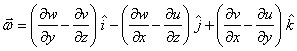
The atmosphere circulates around the planet in a wave-like fashion. One of the components of these waves is called Rossby Waves. Rossby Waves are waves formed due to Coriolis Force as air circulates around the planet at different latitudes. Changes in--yes, a scary weather term: Vorticity--(one of the most fundamental driving forces in planetary atmospheric motion which causes the overall weather patterns) change the dynamics of the wave. (If you’re wondering--and I know most of you are--what the equations that are used to describe the changes in vorticity and ultimately weather patterns, check this out.
 Maybe all of you will think twice before mocking the local television weather guy or gal. We had to study and memorize this stuff! (Thank you Dr. Pasken)
Anyway, these Rossby Waves are not uniform so they tend to fluctuate in intensity as they circle the northern hemisphere because of changes in vorticity. Often times, a Rossby Wave will develop an upper level low over Hudson Bay in Canada while a strong high pressure cell becomes entrenched over the North Atlantic.
This upper level high (at an altitude of 18,000 feet) often migrates a little to the west or to the east throughout the year.
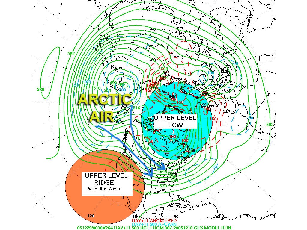 This fluctuation in the position of this "North Atlantic High" directly effects how much arctic air is funneled down over the eastern 2/3rds of the
 If the NAO is positive, the weather across the eastern US and
Right now, as of this writing (December 18, 2005), we are in a negative phase of the NAO. This would explain why the average high temperature for the first 18 days of December has been 25 degrees whereas last year it was 42!

Incidentally, The NAO also exhibits significant variability over multiple decades. For example, the negative phase of the NAO dominated the circulation from the mid-1950's through the 1978/79 winter. Those of you who remember those winters back in the late 70s, the NAO was the reason for it.
The near record cold notwithstanding, ski resorts are reporting some of the best business this early in the year in quite a long time.
The million dollar question still remains: What is the rest of the winter going to bring? It seems as if the NAO is starting to change toward the positive which would suggest that January will bring less cold air outbreaks. At this point, I welcome a weeks worth of 40+ degree weather. But in this age of supercomputers with weather models containing partial differential equations that would make the most sure-footed mathematics major cringe; there is still no guarantee in weather forecasts. Stay tuned.
No comments:
Post a Comment